The Beacons Way

Where: Bannau Brycheiniog, formerly Brecon Beacons National Park in Wales

Distance: 100 miles across the whole park. I walked about half through the central and most picturesque central section that avoids big roads and towns.  

Difficulty: Easy. The terrain is undulating with small mountains, but paths are very well maintained and graded.

Navigation: Easy to follow trails as there are no trees and the landscape is open. Trail easy to find on OS Maps app.

How to get there: Public buses to either starting points or mid sections (Storey Arms car park below Pen y Fan or Glyntawe Outdoor Centre car park).

THE HIKE

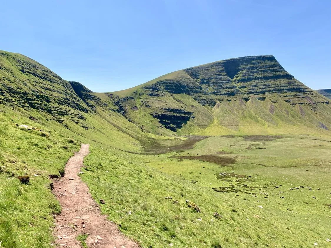
I love the Beacons. In good weather, the endless 360 views of green mountains with their iconic, characteristically textured drops, are perhaps my favourite in the entire UK. The terrain is simultaneously wild and so gentle. No climbs are too steep or too long. The lakes are stunning and perfect for swimming on a hot day. You can choose between around 700 000 perfect wild camping spots. I would hesitate to recommend this 2-3 night variant for bad weather weekends as the views will be very limited, but for a good summer weekend it is simply unbeatable.

A slightly dry Llyn y Fan Fach from the top of Black Mountain

 Glyntawe - Llyn y fan fach

When you live in London, the Bannau Brycheiniog seem far away. I had been to the national park once before, in October 2021, less than two weeks after having abdominal surgery. I fell completely in love with the area and had been dying to go back ever since. I don’t have a car, but also desperately wanted to make the most of the late May bank holiday weekend. Turned out public transport links were actually decent!

I knew I wanted to spend a night at Llyn y Fan Fach lake, and I had agreed to meet some friends to summit Pen-y-Fan on the last day. That left me with the task of plotting a route across the entire western Beacons to the centre in two days. Armed with OS Maps and two packets of Smarties buttons, I set off at 05.40 from London Paddington. I took the train to Swansea and a bus (avg passenger age: 84) to the tiny outpost of Glyntawe. There was only really a tavern and some farmhouses. The trailhead lay right off the small car park on the west/true left side of the road. The trail goes through two gates and a pretty meadow next to a river. Refill water here if needed as you won’t have another source until the lakes. The path takes you along a stone fence and up to scale your first hill. After a moderate climb, you’re standing on a rounded ridgetop, having crossed the Nant Tawe Fechan, and arm of the river Tawe.

Llyn y Fan Fawr

From here you will hike inwards, towards the two stunning lakes with the enormous Black Mountain on your left. You can choose between the trail that goes along the top or the bottom of Black Mountain (not to be confused with the Black Mountains at the eastern end of the Beacons). I would recommend walking the lower route westward towards the lakes and walking the top route back out towards Glyntawe. That way you get to appreciate the amazing look of the mountainside one way, with the top-level views of the lakes the other way.

The path takes you along the shores of Llyn y Fan Fawr (pronounced vaorr), where plenty of people swam and wild camped on the blazing hot day I hiked here. This is where the trail splits up towards the top of Black Mountain (Fan Brycheiniog) or continues along its base. Llyn y Fan Fawr is gorgeous, with lots of little sandy bays it is perfect for a dip. Keep to its eastern shore, and the path will take you northwest as you digress slightly from the base of Black Mountain. Here the landscape opens into those beautiful open vistas the Beacons are so famous for. You can eventually choose to stay out in the open or trace the base of Black Mountain towards Llyn y Fan Fach. The lake itself is impossible to miss, as it is nestled where Black Mountain ends, with the mountainside swooping steeply down in a C-shape around the lake.

Fun fact: Welsh ponies come in four categories based on size, this mare is a category B.

Semi-wild Welsh ponies graze freely here. They are a lovely breed, with big eyes and intelligent Arabian-like concave faces. You’ll see their fluffy foals (some of whom look like woollen mittens!) throughout the warmer months. I did see herds of cows on my second day, but they mostly graze slightly lower in the valleys. Note that the presence of animals means that you must not drink water from the streams without filtering it. This should go without saying, but I’ve seen so many people in the UK drink water straight up in these areas!

Destination: Llyn y Fan Fach

Camping at Llyn y Fan Fach means that the first day is relatively short and the second is quite long (30 km), but it also allows time for travel, and an afternoon basking by the lakeshore is time well spent! I pitched my tent on a spot of perfectly flat ground in the innermost corner of the lake, directly between the giant shadow of the mountain. There’s a road that leads directly to the lake (where there is a dam), and so you won’t have it all to yourself. I saw at least two other people wild camping on the lakeshore. I had a glorious afternoon of swimming, lying in the sun, and making my trail dinner inbetween the pale rocks on the lakeshore – before nestling in for a warm night.

Home under the mountain

Llyn y fan fach - Craig Cerrig Glesiad

Oh boy. You’d think that after 130 nights of wild camping, I would sleep at least tolerably in a tent by now. The night had been balmy and quiet, but I’d felt oddly unsettled and struggled to fall back asleep every time I awoke. Thank god no one was there to see my wrinkly morning face. Today was a 30 km whopper all the way across the west and central Beacons.

I climbed the western slope of Black Mountain in a fierce gale wind, passing a sorry sod who had camped up there “to test whether his tent was windproof”. While the structure was still standing, I cannot fathom how he got a wink of sleep surrounded by flapping nylon. Llyn y Fan Fach glittered a steely blue in the morning light. I powered along the dirt trail all along the summit ridge for several km.

Stunning morning views of Llyn y Fan Fach

The trail swooped steeply down towards the edge of Llyn y Fan Fawr. Walking back the same way was a breeze, and I was back in Glyntawe before I knew it. The day had been overcast until then, but as I lunched by a roadside pub alongside a group of scouts, the sun pierced through and bathed the valley in brilliant light. It was the May/June bank holiday weekend, and prime hawthorn season. Every bush and tree in the whole valley were cotton clouds of white flowers.

The climb out of the Glyntawe valley and up towards the wild central Beacons was slightly confusing. Make sure you have your route plotted into OS Maps or another trail app, as old trails have been blocked by a stone quarry. Once you have regained some height, the path becomes wilder. Follow wide tracks along a stone fence that takes you eastwards and away from the valley view. You’ll soon be on a gravel road which climbs to the high point of the way – from the top you can see Pen y Fan in the distance.

Here begins a long stretch on small paths through the grass. This is a much less travelled park of the Beacons, and I didn’t meet a single person for hours as I strode past Fan Gyhirych, Fan Need and Fan Llia. Any of them would be a fun addition to this stretch but would add more (and steeper) mileage to an already long day.

I was getting proper tired and started looking for campsites by the time I crossed Sarn Helen Road. There was still not a single human in sight. There were, however, herds of cows around. Ever since I was attacked by a cow in the Spanish Pyrenees on the GR11, I have avoided bovines at all costs. I didn’t want to camp within a 5-mile radius of anything with horns. Onwards from Sarn Helen, the “path” on my map wasn’t more than faint sheep tracks appearing and then disappearing in the long grass. I climbed up the ridge of Fan Fawr off piste among the grey sheep.

Hawthorn bloom

From the top, a vast valley spread out before me. It was late now, and I was tired. Yet more cows and no trail. To the south I could see Ystradfellte Reservoir. It had been a hot and dry year, and its river arms Nant y Gaseg and Nant y Gwair trickled only shallowly through muddy banks. The water situation wasn’t great, and as I crossed the valley and started up the final slope of Craig Cerrig Glesiad, I realised I would have to dry camp in order to escape the cows. Eeeergh.

Pen y Fan in the far distance

I stuck my filter in the dark marsh water and squeezed as hard as I could to fill up my water bottles. My little Katadyn BeFree bladder squealed in protest. At this point, I was getting a bit desperate to find a flat piece of non-boggy ground. Just as I rounded the mountainside, a little flat opened up with two grassy shelves perched next to each other. The top shelf was taken by a 40-something man and his tent. There was nothing for it, I just had to share.

Home number 2

Turned out, he was a sociable fellow, incredibly another Chris who also worked in defence. We had a merry conversation as I battled the winds to set up my tent and make tea and dinner on my gas stove. My honey and spice rooibos tea bag read “inner strength”. Did they have a “hamstring strength” one? Spiritually I was all in. But I was shattered after the long day and lay paralysed on my sleeping pad for an endless hour until the sun started setting.

Sunsets in the Beacons are a league of their own. The endless expanse was entirely bathed in liquid gold and dark pink. With views for endless miles and Pen y Fan straight ahead, I snuggled into the two sleeping bags I’d brought and stuffed my earplugs into my brain stem against the wind.

Craig Cerrig Glesiad - Storey Arms Car Park via Pen y Fan and Cribyn

I woke up to the most spectacular sunrise after a very windy night on the ridge. The sun rose up behind the Pen y Fan summit at 05.30, a sight it was well worth waking up for (before going back to sleep obviously). My friends were driving from London, and so I had the whole morning leisurely to myself. I made my double chock mocha coffee (at 28 I still have an embarrassingly juvenile coffee taste) and packed up my little camp in the bright blue morning. Chris had already left, and I was completely alone. All there was to do was stride downhill to the road, cross it, enter the already packed Storey Arms car park, grab a pancake-flat cheeseburger from the food truck (nowhere but the UK…), and lay down by the river to tan and wait.

If you think you’re not fit enough to hike up Pen y Fan, let me assure you, you are. Amongst the people who passed me were two women in flip flops, a guy in a full suit, and a sausage dog so fat and short, its stomach nearly dragged on the ground. If you have legs, you can climb this mountain.

I had a joyful reunion with Mann, Harper, and Sarah, and we began the gentle climb up towards the summit. This is always the most trafficked part of the Pen y Fan hike, you’ll almost be walking in a queue, the crowds luckily thin out considerably towards the top. If you have a car and are not doing the Beacons Way, you can ascend from Neuadd carpark instead for a longer but less crowded route (read my guide to that loop here).

Pen y Fan summit

Mandatory photo at the summit plaque, which felt almost embarrassing considering we had barely walked 45 minutes to get there. The wind was so fierce we had to don our puffies despite the clear blue skies, nearly losing them as we wrestled them on against the gales. Sarah’s petite form looke like it could blow right off the mountain, and we nestled down for a long lunch. A red kite soared over us for over half an hour, riding the winds and undoubtedly showing off to the gathering audience.

View of Cribyn summit and Sugarloaf mountain in the distance

My favourite part of this day hike is the route between Pen y Fan summit and its smaller neighbour, Cribyn. The crowds disappear, and we had the trail all to ourselves. While Pen y Fan has flat twin summits, Cribyn sticks up more like a traditional peak. A dirt path and stone steps take you through the V-shape between them, with the final summit climb up Cribyn being the steepest part of the hike. I was in peak shape and jokingly coaxed the others along – I probably looked so extra with my 65L pack and trekking poles.

Windy views

The view of Pen y Fan from Cribyn summit is spectacular. You get views of the textured part of the summit, which is so characteristic to the Beacons and a top photo spot. There isn’t a single tree to shelter from the wind, but the expansive views are unparallelled. Alas, the day was waning, and this was the end of my hike. After a too-short photo stop we had to turn around and hike back. I could have hiked another 10 km now that the wind had finally died down, but the long road to London wasn’t going to get any shorter.

Harper and Pen y Fan

You can easily add on another night to this hike, which would be well worth the views, by adding on Fan y Big and Allt Lwyd mountains before descending back into civilisation. I hope to do this the next time I’m back in the Beacons! These additional miles will add almost nothing to the altitude profile of your hike, as the mountains are table-top formed, once you’re up you stay high.

Three security researchers and a mountain

Almost everyone else had gone by the time we meandered back down towards the car in the afternoon sunshine among Welsh ponies and the sheep. We piled into the car and sped off back to London, Mann and I exchanging amused glances as our two junior friends, “the kids”, fell asleep in the back.